Long distance traveling. I love it! The challenges, the fear, the sights, the people and the solitude. The newness of the world slowly replacing the daily monotone as each day passes. If you travel longer than a week you begin experiencing things very differently. You are far from home and the old you has been replaced with a new one and you start seeing things very differently. It is the duty of the intrepid traveler to see this transformation, albeit temporary, and learn from it. Learn about oneself and bring about a change however small.
I jump at every opportunity to travel. But they don’t come my way as often as I’d like though. I have grown to appreciate the value of slow travel over the years and as the name suggests it requires more time and doesn’t blend well with full time jobs of the modern world. You get to see more and experience the places you visit with more quality (or maybe a different kind of quality) than a whirlwind of a tourist visit. Motorcycle travel somewhat allows slow travel. You are restricted to traveling by land experiencing everything with all your senses now exposed.
I had long dreamed of traveling to Alaska. After watching countless photos of people taking cruises, kayaking, hiking and flying around the great glaciers and high mountains of the Denali range I had had enough. I felt it was time for me to go to Alaska and of course it had to be overland! My previous visit to Mexico overland gave me enough confidence to take up this longer ride from San Jose, California to Alaska through Canada. Almost 7,000 miles overland, round trip.
Such a long journey can do with an expedition. My roommate Abhi, who had come along for the Mexico trip, was more than keen to make this trip. We planned to make this month long trip in early August. We applied for a Canadian visa in preparation. This however seemed to be a tough task. Summer time was peak tourist season and after many months of arduous applications and wait we were in possession of the visa that would make this overland journey possible. Unfortunately our dates had to be pushed out to end of August and we had the perilous task of riding close to approach of winter.
Due to the nearing winter our plans of riding the Dalton Highway from Fairbanks to Prudhoe Bay on the shores of the Arctic Ocean was already washed out before we could start. High arctic winds and snow had made two wheeled traffic on the 300 mile, complete gravel, ride to the very top of the North American continent a dangerous affair and I had no intent to tempt fate and poke Mother Nature with a stick. This instinct of mine played a role many times during this trip. The goal was now to try and make it to Fairbanks and explore Alaska for a week before heading back down.
As luck would have it as the D-day neared Abhi had to drop out. Situation did not allow him enough time to make this trip overland. He decided to cut short but still try to make most of it by flying to Alaska. I was left with a choice. Ditch the overland idea, fly to Alaska as well and also make sure that I have some company or continue with the overland idea and do it alone. Funnily I didn’t really delve much on this. Very quickly it was clear to me, as clear as the summer days we were having in San Jose, that I want to do this whether I have company or not.
I continued preparation and soon was ready to leave on the 28th of August. Preparing for this trip was much easier compared to the previous ones. I guess practice makes perfect.

Following are notes from my journey interspersed with photos I took. Read on to see the journey unfold. The wondrous beauty of the pacific northwest followed by the great white north. The highs and lows of solo travel. The authority of weather. The fragility of travel on a motorcycle. How a journey can take unfortunate turns, balk the travel just few hours short of the destination but still continue on with the experience without missing a beat.
August 28th 2014
The first day of the journey. Learning from previous trips I made sure I had a short distance to cover. This allowed me to spend some time in the morning finishing up some last minute tasks.
I finally left San Jose at around 12pm. I had only around 300 miles to ride to my stay for the night at Weed, California at the edge of Mt. Shasta national park. It was just 300 miles but the heat today made it very tough. The route I chose took me inland where summer is still alive and kicking. The temperature was in the low 90s and jumped to low 100s as I drove further inland towards interstate 5 north.
The route was mostly straight and the scenery mostly brown until I reached Shasta national forest. The temperature dropped, the roads started to curve and the scenery turned green. The tall green coniferous (pine I think) trees were like a thick green plumage covering the mountains at some places and like a prickly hide at other. The roads were wide, weaving and freshly paved providing fantastic traction.
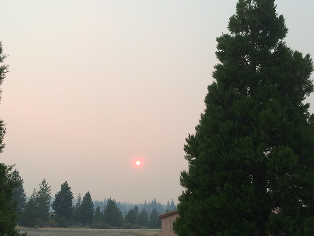
Around 7pm I reached Weed, California which was covered in smoke. The smoke hung low and made Weed look like the lair of a spliff smoking giant. The red sun in the distance like the smoldering end of a spliff hiding the monster in the smoky haze. Apparently there is a forest fire a few miles away which made Weed hazy.
I checked into a motel and based on the receptionist’s recommendation headed to a Mexican restaurant called Dos Amigos for dinner. A very interesting place. Lots of tourist buses filled with Spanish speaking folks were crowded outside. This restaurant also has a variety store interspersed with it. It’s run by a Chinese guy with Hispanic staff. This person was stockily built and rocked a military hair cut. Very gregarious and spoke on a variety of topics. He spoke fluent Mandarin, Spanish, Hindi, Bengali, Punjabi and of course English. This convinced me to sit and eat at the restaurant instead of taking the food back to my room. He said the chips and salsa were as good as any pani-puri. I had them and agreed. He spoke of a friend who ran a Chinese restaurant in Pune. All of this pretty much blew my mind and I just quietly listened to him talk. As I left he let me in on his secret. He was actually born in Calcutta, India and probably moved to the US a while ago. This explained everything and I rode back to my room very impressed at the randomness of the world.
August 29th 2014
Today was my first morning on the ride. I woke up early enough to get ready, have breakfast and get onto the road by 9:45am. I decided to ditch the interstate I-5 and take the back highway US-97 cutting straight through Oregon. I had not heard of this route before and took a gamble. It paid off quite well. US-97 north took me through wondrous vistas today.
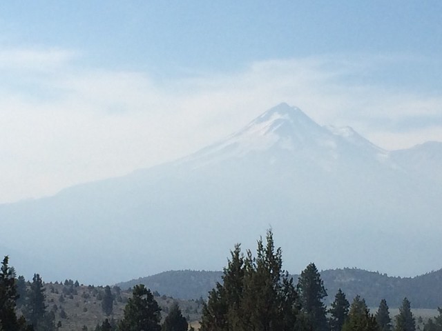
It snaked around Mt. Shasta and gave me a near 360′ view. At first I could only see the rocky face of the mountain rising high and mighty over the little town of Weed. It was plain and a bit disappointing. But as the road curved the northern face of Mt. Shasta covered with glaciers glistening blue in the morning light began to show. I had to stop multiple times as each angle was better than the next.
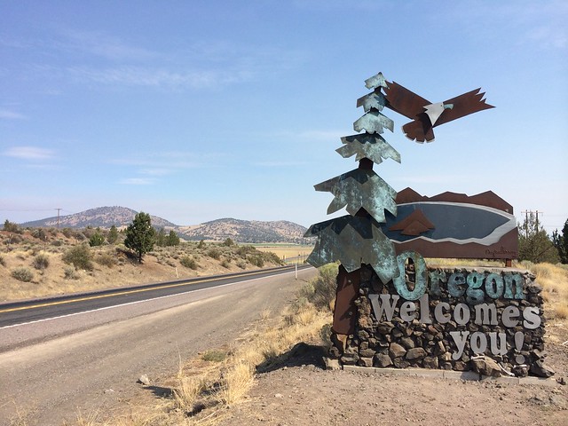
I entered Oregon around 11am and was immediately surprised by its simple beauty. I was expecting more of what Northern California looked like. It was similar but there was certain sense of soft, rustic homeliness to it which made everything sweeter.
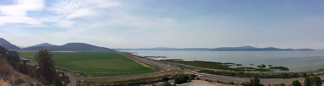
The route bordered the greater Klamath lake which seemed big. There were mountains bordering it and had small roads running up and down. I took one of those turn offs and rode up high enough to get to see almost the entire Klamath lake. I don’t usually veer from the set route. But this impromptu choice made me glad.
The detour to the famous Crater Lake and back would have added another 80 miles and two hours to my day. To keep the day short I decided to skip it but promised myself to see it on the way back.
The next 150 miles were through the Winema and Deschutes National Forests. It was mostly a two lane straight highway lined with Pine trees. I stopped a few times to drink water and make sure I was hydrated. There was decent cloud cover and as I approached Bend, Oregon for lunch the sky opened up to make some good cloud shows.
I stopped at Redmond, Oregon for a cold coffee at the local Starbucks. While I was sipping my coffee a lady walked up to me and said “Italiano??”. I said “No… Indiano”. She mistook the Italian colors on my helmet for my nationality. I almost felt bad for letting her down. Not that exotic. Just a regular Indian from the Bay Area fooling around.
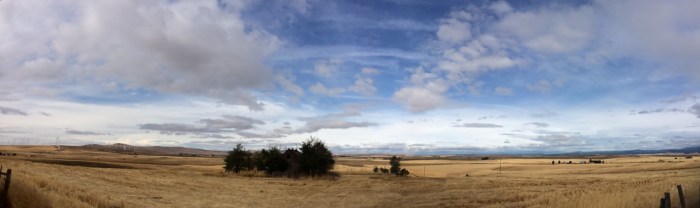
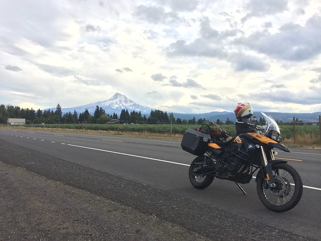
At Madras, Oregon I took a slight detour off US-97 onto US-26 which was 30 more miles but took me through the Warm Springs Indian Reservation. This is where the beauty of Oregon shone its brightest. On your left are vast green meadows grazed by cows and horses with the majestic snow capped Mt. Jefferson standing behind them with its summit floating with the dark, gray clouds. Straight ahead was the smaller Mt. Hood with wisps of white clouds circling its summit. The Warm Springs indian reservation had it all. Canyons, green mountains, valleys, tree filled gorges, swift rivers and dramatic clouds with the constant backdrop of Mt. Jefferson and Mt. Hood. It was fantastic and made me grin.
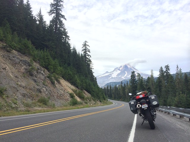
The reservation led to the Mt. Hood National Forest which had a single lane fast sweeping road running right through it. The tall forest blocked out most of the light and I couldn’t see the mountains anymore. The road was in great condition and all the vehicles kept good pace. I was riding in the zone. The weather got colder as the elevation increased and once above the tree line Mt. Hood raised its err.. hood. It was cold and reminded me that I need to make sure I have proper warm clothing for Alaska.
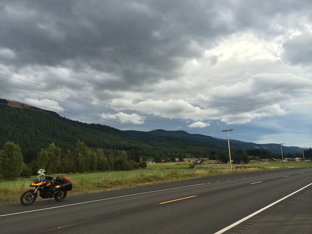
As I rolled down the mountains it got warmer and brighter and opened up into small farming villages which didn’t have the usual heavy machinery tilling the fields. These were smaller farms with lush green fields next to small brightly colored cottages lined by wooden picket fences and wild flowers. There were small dirt roads leading into the fields. The sun was setting behind these fields and through the clouds were casting a light grey hue on Mt. Hood. I spent a good deal of time here.
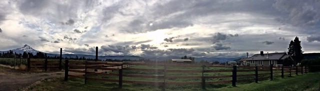
I reached the Columbia river forming a geographical border between Oregon and Washington and rode east along the river towards The Dalles where I had booked a motel. The snaking road along the snaking river bathed in golden hour light made for a satisfying finish to this beautiful ride through the surprisingly beautiful Oregon. I will come back to you Oregon, I will.

August 30th 2014
There are good days and there are bad days. Today was a mix of both which saw me ride from Oregon all the way through Washington, cross the Canadian border and arrive at Vancouver, British Columbia.
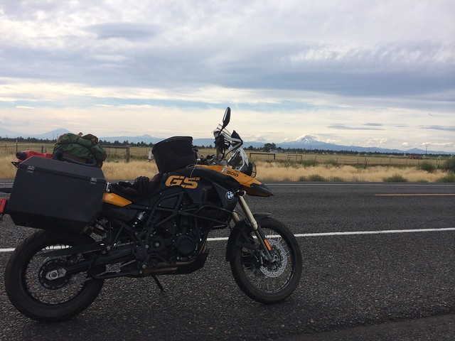
I got a good early start from The Dalles around 9am. A short while and I had entered Washington across a narrow bridge over the Columbia River. I rejoined US-97 which climbed steadily into the highlands of Goldendale which truly lived up to its name.
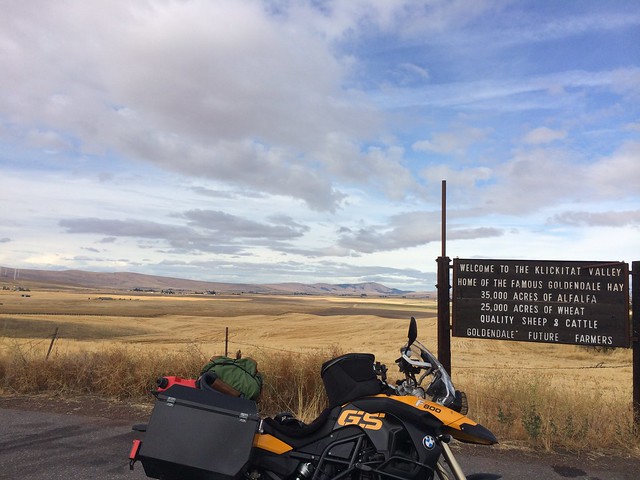
Late summer and all around me were vast fields of dried golden hay of Alfalfa and wheat crops.
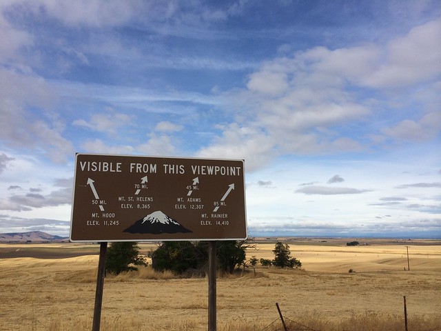
In the distance on a clear day one could spot 4 different peaks.
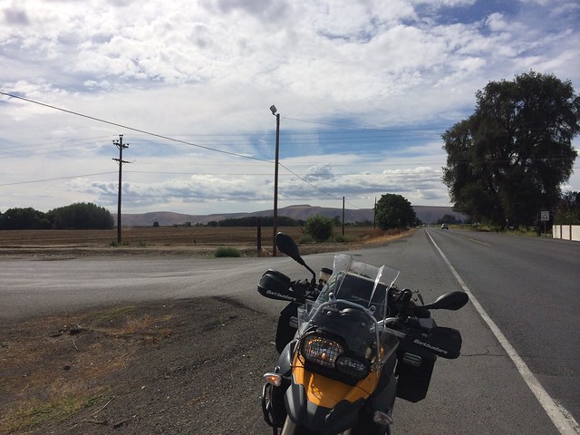
I continued on to the Yakima Nation Reservation which was another Indian reservation. I love riding through Indian reservations. They are always beautiful and It show a very different type of life in America. One of these days I will stop and chat with some locals.

Right after Yakima, the city, is a turn off for Hwy 12 West which leads towards Mt. Rainier National Park. I decided to take this detour to visit the most famous mountain in Washington. Hwy 12 starts of nice and easy and soon starts gyrating around Naches River and later switches partners to Tieton River. They switch sides playfully and cast askew glances at each other. It was a treat riding this bit. Motorcyclists and cars on the road in a smooth flow and rafters, kayakers flowing down the rapids in the other direction. There were beautiful bends where the river was parted by a tiny spit of land filled with greenery and a despicable advertisement board by realty companies. The weather was good too. Just cloudy enough to block out the sun but not the light. I stopped for a bite and some photos before heading on.

Hwy 12 soon enters a deep tall forest and starts gaining elevation and crosses over White Pass where you can see winter time ski lifts waiting impatiently for the snow. At this point the road slowly descends into a valley. It turns windy and quite dangerous at some points. To add to the tough road conditions the weather took a turn for worse and wouldn’t get any better for the next few hours. It started to rain a bit and the temperature dropped considerably, as low as 50′ F. On the positive side all this rain meant clouds and here there were beautiful low hanging ones which hid all the mountains and their peaks. I stopped multiple times for photos.
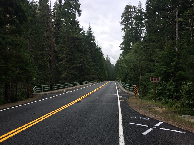
I veered of Hwy 12 onto Hwy 123 which took me straight through Mt. Rainier National Park. This route usually closed in winters was wet, cold and beautiful. It’s a narrow road with tall trees lining it.
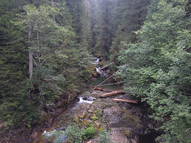
Every mile or so the tree wall would break allowing cascading streams through. Crystal clear water falling multiple times, gathering in large blue pools before running further down the mountain.
The narrow Hwy 123 ends at Hwy 410 which leads you out of Mt. Rainier National Park. I stopped at a cafe where I was told that this was the first wet day of summer. How unfortunate. I never did get to see the full Mt. Rainier. In fact I couldn’t even tell which one of the mountains it was. By this time I was quite damp and assumed that since the mountains are behind the weather will get better and I will dry up. Boy was I wrong. The sky got darker and cloudier. It changed from a drizzle to a downpour for the next 50 miles.
I arrived in Seattle at around 4:30 quite drenched. Boots, socks, pants, jacket, shirt. I made my way to Ride West BMW where I had to pick up a heated jacket for use further up north. Having seen the near complete failure of my rain gear I thought it prudent to fix that. I spent an extra few hundred dollars on proper rain boots, pants and jacket at the store. I left the store feeling like an astronaut or a high mountain climber under all that gear. At least my wallet was a bit lighter now.
Now that I was waterproof Murphy made sure that it didn’t rain. So, I got good weather all the way from Seattle until Vancouver.
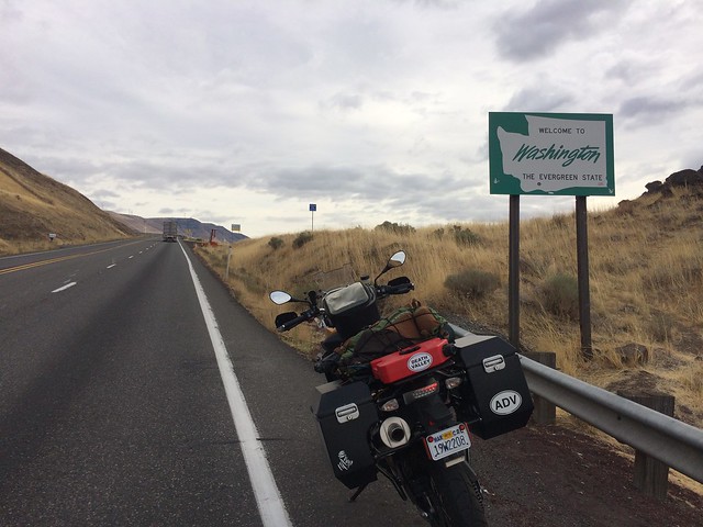
It being a long weekend the border crossing was slow. It took me around 45 minutes to cross the border. The stern officer at the border made sure she knew the whats, hows and whys of my trip before letting me through.
As soon as I crossed into Canada around 9pm everything looked the same but a bit different and I dare say better. It was the metric system. Distances and speed now made sense. The thin veneer of the US measuring system I has gathered over the years started flaking off.
I made my way to my relatives place in Vancouver. I passed through suburbs which were quiet and empty and soon ended up in the bustling downtown area. I was to stay at one of the high rises in downtown. It had incredible views of the Pacific. It was a long day and I hit the sack as soon as I could. A day or two of break in the journey would do me good. Recharge my batteries and prepare for what’s coming next!

That is some roadtrip! We long evaluated driving from Calgary to Alaska when we went there late this summer … But with limited vacation we ended up flying and renting a car instead. I still want to drive the Alcan highway…but I might have to wait until I retire in about 30 year to have enough time for it!
Thanks! I didn’t have enough vacation either. I managed to convince my boss to let me go with some unpaid leave. Was worth it. 🙂
I hope you get a chance sooner.
Lovely writing Sampath! Really enjoyed reading this one. 🙂
Thanks Shriya!
Enjoyable reading. Waiting for the next set up updates 😉
Thanks Karthik! Updates coming soon. 🙂
Pingback: The Alaskan Odyssey – II | Nobody Going Nowhere
Pingback: The Alaskan Odyssey – III | Nobody Going Nowhere
Pingback: The Alaskan Odyssey – IV | Nobody Going Nowhere
Great post! Feels like I am doing the trip with you! Looking forward to the continued parts.
P.S. O’desi, I am calling you Indiano henceforth…… 😉